Open Source computing for UK businesses
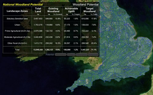
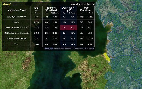
Woodland Potential Calculator
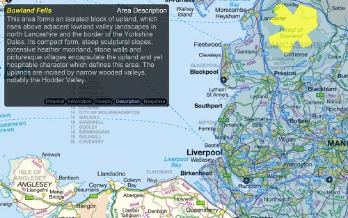
In 2010 the Forestry Commission and Natural England started a project to assess the potential to increase woodland cover across the north west of England. The region was to be sub-divided by landscape type using the established definitions of the Natural Character Areas. Data would be compiled by coordinating a series of meetings of local experts who could make reasoned assessments of both the opportunities and the constraints for woodland creation within each area.
The agencies decided that they needed a suitable computer based method of gathering, collating and presenting this information. Michell Computing had previously worked on a number of data presentation and distribution systems for the Forestry Commission and we were invited to tender for the software development aspect of this project.
Development Process
The project brief required the application to be capable of use within a presentation whilst also enabling direct text entry into an on screen table. It would also need to be distributed to an initially unknown number of people and the data created by them, would need to be returned (preferably as e-mail attachments) back to the project co-ordinator. The software should finally be capable of aggregating the areas into an informed assessment of the potential for woodland creation across the region as a whole. It was also desirable, although not a requirement, for the system to display a location map to give some context for the displayed data.
Our initial trials were with various VBA scripts running within Microsoft PowerPoint and Excel. However, each test presented a number of limitations. In addition, the best we could achieve for contextual mapping with this approach was a series of pre-rendered static maps.
Because of these issues we swapped to evaluating the feasibility of a bespoke solution. The short time-scale for delivery restricted the scope for starting entirely from scratch. Fortunately, we could re-use some mapping code from previous GIS projects and this, combined with an excellent open source graphics library, gave us a sound foundation of tested code.
We developed a small proof-of-concept sample and our proposal was accepted and we were commissioned to write the actual application. The software had to be developed rapidly to be ready for the start of the scheduled series of meetings. This required very short development and testing cycles, but with excellent technical feedback from various staff members at the two agencies, we were able to deliver a stable implementation of the application in time for the first meeting.
As a result of the project's success in the north west, both agencies decided to extend the scope of the project to assess the whole of England. Over the course of 2011 the software was considerably extended to incorporate national scale mapping, various requested refinements and to present additional background information for each character area. This revised system is now being used to compile the National Woodland Potential dataset for the whole of England.
Technical Description
Our in-house mapping engine was originally written in Delphi. Severn years ago this was ported to FreePascal (an open source implementation of ObjectPascal) using the Lazarus code editor and LCL application library. This has proved to be a very robust platform for general purpose field mapping. It is too large a code base for this project, but it was useful as a source of ready tested code for rending map geometry and reading Well Known Text (WKT) format data.
The graphics library was the excellent Graphics32 again originally written for Delphi but successfully ported to FreePascal a few years ago by the project's developer team.
Background mapping came from a variety of sources. The base satellite image is actually NASA's Blue Marble data. Several other backgrounds were produced using Ordnance Survey's OpenData. The Land Use backgrounds were produced from the Forestry Commissions own land use research data.
This project is also significant in that it is the first fully open source commercial project undertaken by Michell Computing. The application and the source code are now freely available on SourceForge.